transitdiagrams
-
Posts
405 -
Joined
-
Last visited
Everything posted by transitdiagrams
-
affinity designer Bern / trolleybus, tram / transit maps
transitdiagrams replied to transitdiagrams's topic in Share your work
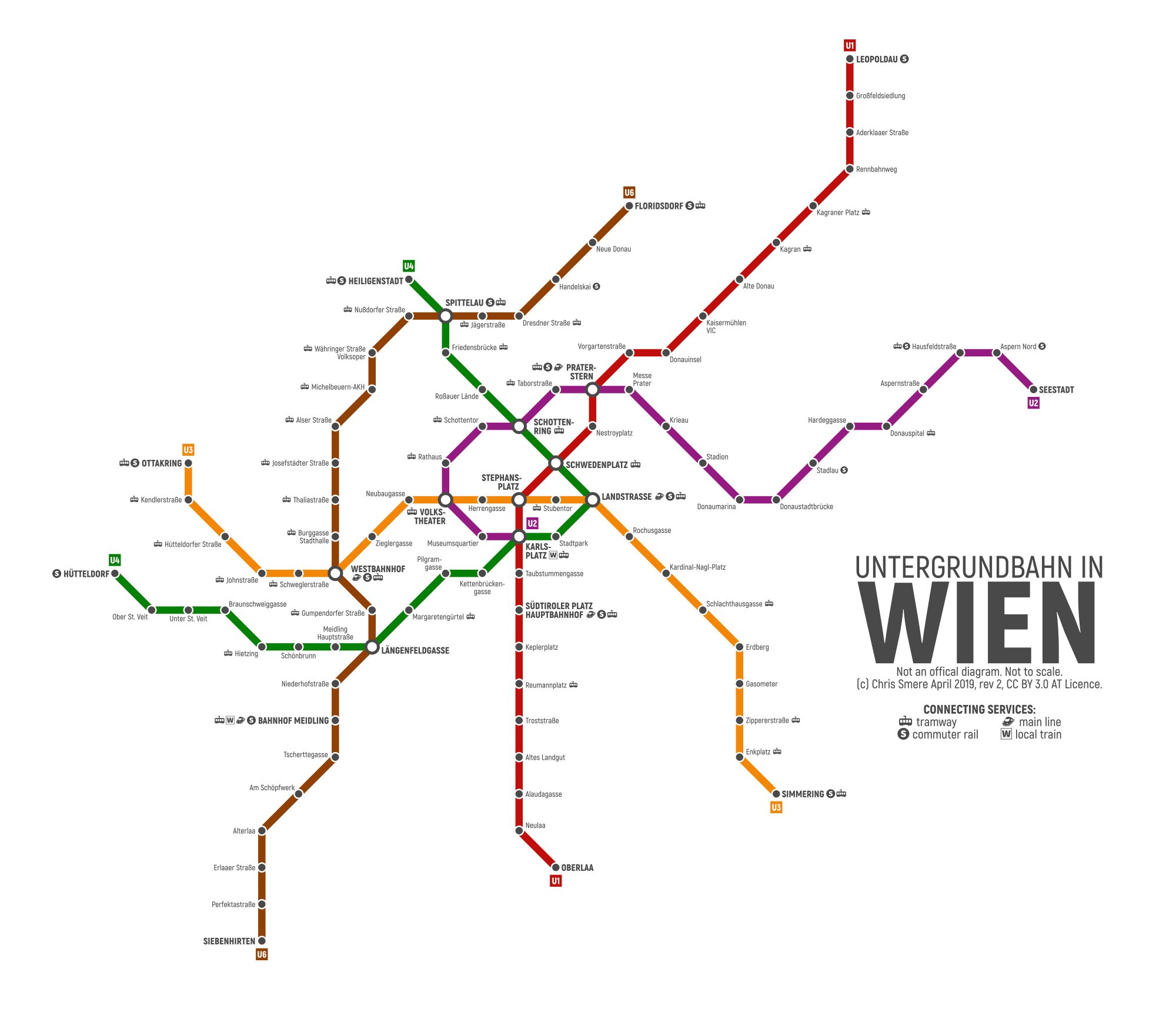
PS: @AlainP, @Alfred that's the ubahn situation right now in Wien/Vienna:
- 12 replies
-
- 3
-

-
- bern
- switzerland
- (and 5 more)
-
affinity designer Bern / trolleybus, tram / transit maps
transitdiagrams replied to transitdiagrams's topic in Share your work
Thank you, @AlainP! :-) As @Alfred already pointed you to my Vienna map I only have to add my version shows also not yet existing lines and configurations (U5 for example is underconstruction and U2 goes to Karlsplatz till the U5 is finished). I know what you mean but I am actually only interested in showing the transit routes without a real city map behind it - would be to much information and overwhelming. But don't worry there are local maps at every station showing what's around. The official ubahn map by Wiener Linien is also in a similar style like mine but additionally showing the sbahn in the Vienna/Wien area too (commuter train network). And also there are city maps with tram, bus, ubahn. :-) My suggestion for a nice sightseeing ride with public transport is taking the Vienna Ring Tram from Schwedenplatz (that's the tourist tram) - or you just can take lines 1 and 2 which do the same but with noch extra fare and normal modern streetcars (just have to combine their Ring sections for a full circulation). The tram takes you around the city center on the so-called Ringstraße which is the main circular boulevard with many beautiful buildings - like the Parlament (Parliament, under renovations now), Rathaus (city hall), Universität (University), Votivkirche (church), Börse (stock exchange), Museum der angewandten Kunst (MAK) (Appplied Art Museum), Oper (State Opera) etc.- 12 replies
-
- 2
-
-
- bern
- switzerland
- (and 5 more)
-
Good evening :-) I do transit maps (diagrams) for fun in my spare time to relax. Here is my interpretation of the Bern trolleybus and tram network. Feedback is welcome. Have a nice start of the week tomorrow! Chris
- 12 replies
-
- 10
-
-
- bern
- switzerland
- (and 5 more)
-
affinity designer Sheffield / Tram / Transit diagram
transitdiagrams replied to transitdiagrams's topic in Share your work
It's been a pleasure :-) and it makes my happy if you like it! Thank you! :-)- 16 replies
-
- 1
-
-
- sheffield
- transit map
- (and 3 more)
-
affinity designer Sheffield / Tram / Transit diagram
transitdiagrams replied to transitdiagrams's topic in Share your work
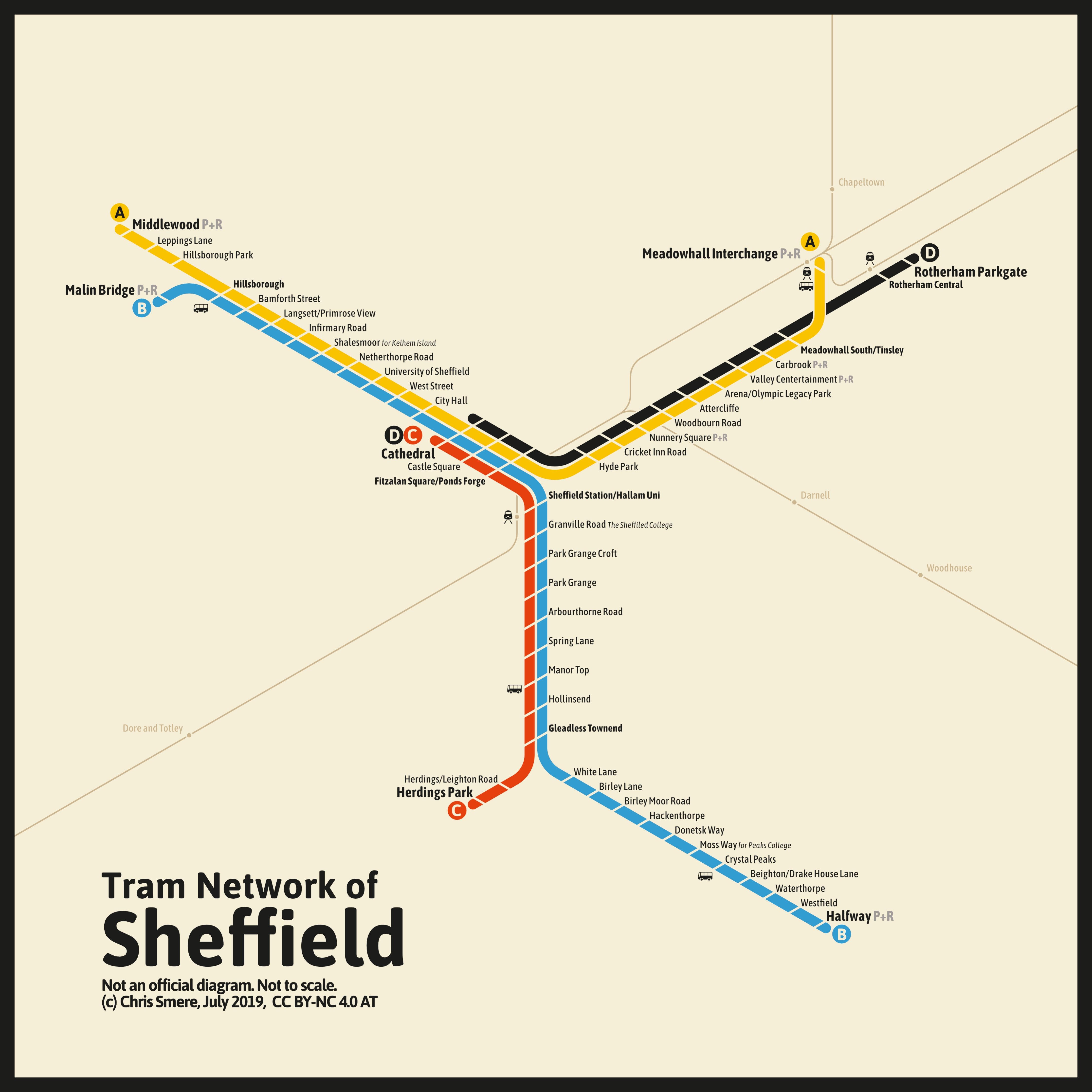
By the way - the original version was with a brighter background. Only decided this morning to go with the beige version. Here is the white version - just for the sake of completeness:
-
affinity designer Sheffield / Tram / Transit diagram
transitdiagrams replied to transitdiagrams's topic in Share your work
Thank you :-) Dankeschön!- 16 replies
-
- 1
-
-
- sheffield
- transit map
- (and 3 more)
-
affinity designer Sheffield / Tram / Transit diagram
transitdiagrams posted a topic in Share your work
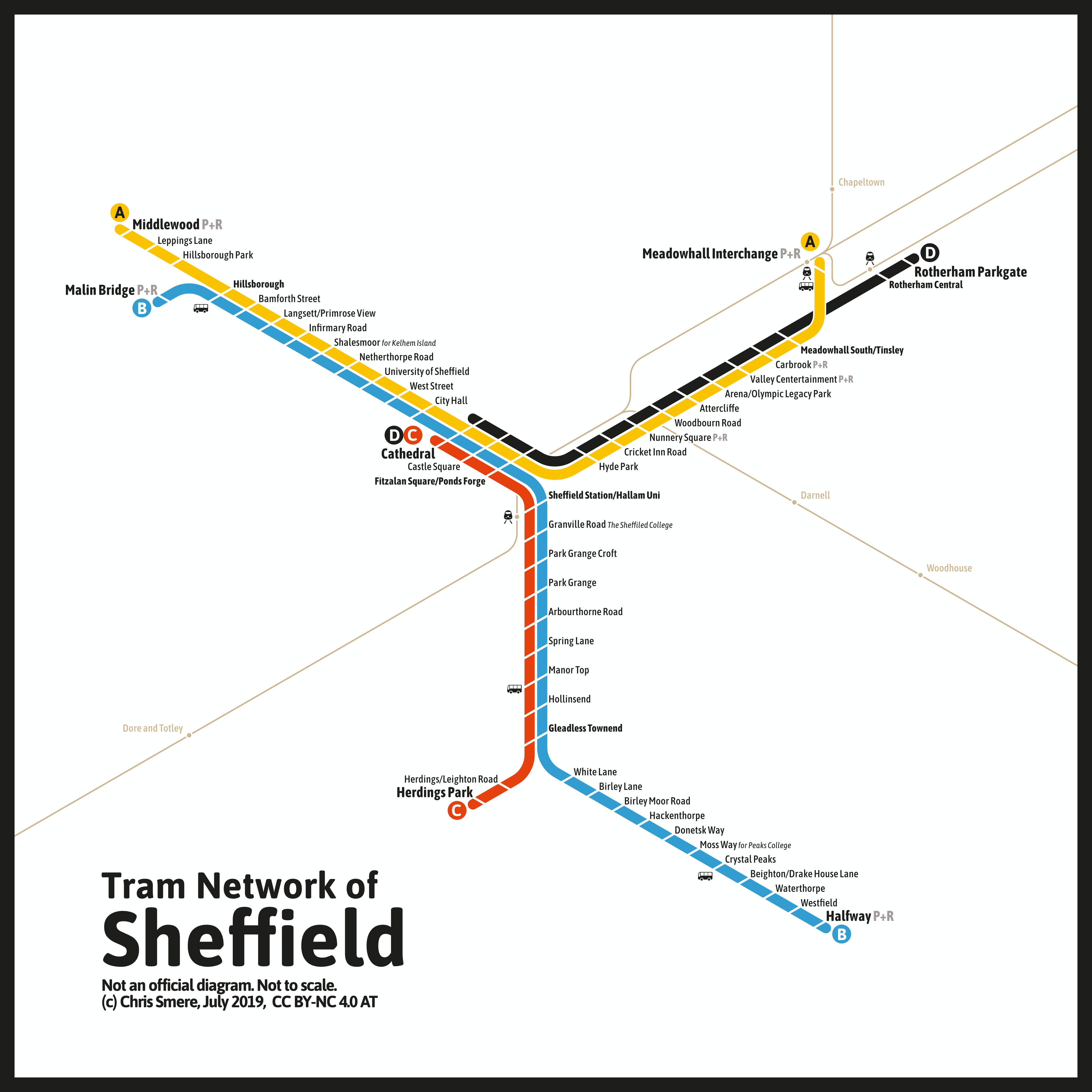
Hey :-) I do transit maps (diagrams) for fun in my spare time to relax. Here is one I was working on this weekend - after a request @Alfred: The Sheffield tram system in my interpretation. I've altered the color palette a little bit (more Bauhaus now) and also introduced route letters. Hope you like and enjoy it - @MattP :-) Feedback is welcome and appreciated of course! Have a great day you all! Chris
- 16 replies
-
- 9
-
-

-
- sheffield
- transit map
- (and 3 more)
-
I think only a few official maps are done as a dark version actually. Montreal's metro map being the most famous. Well, thank you, Roger :-) Most of the time this color concept works very good but it is the most often used. Sometimes is nice to make something different. Does not work all the time though. Thanks a lot :-) Glad you like it!
-
Ahhh that's the background :-) I guess I'll have to do a Sheffield tram map this weekend then! You shall have my interpretation in the next days!
- 14 replies
-
- 1
-
-
- bus
- trolleybus
- (and 5 more)
-
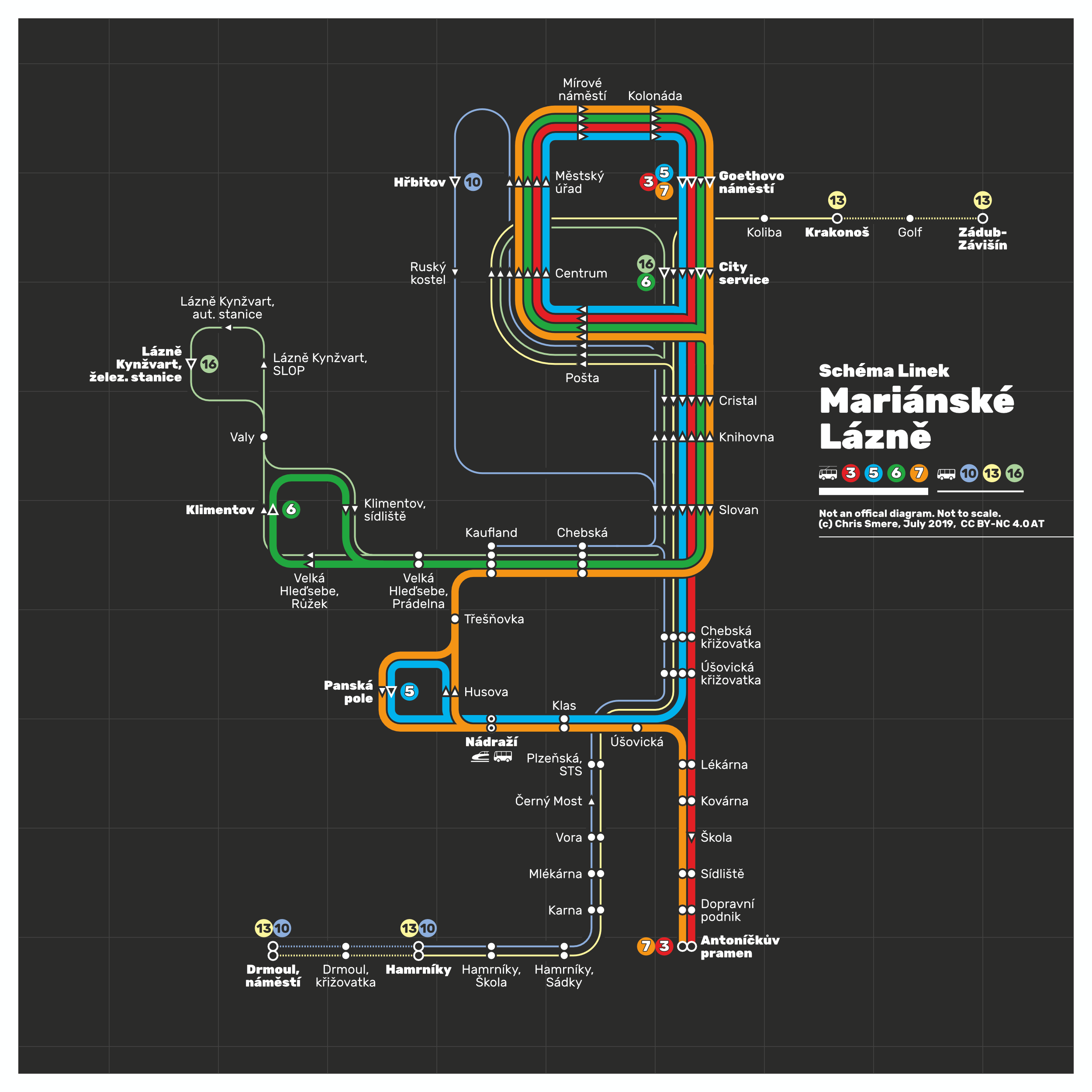
Thanks you :-) What might go on at Panska pole? Just get out one stop before :-) The white outlined ones indicate terminal stations. In general all those arrows indicate the direction of service too. In the while Diagramm i am using a font family called "Rubik". Should be rectangular in all instances. Might be due to compression and resolution. Hope that answers all your questions and concerns for now :-)
-
Thank you so much I am really really grateful! So, I shall keep posting more of them :-)
- 14 replies
-
- 1
-
-
- bus
- trolleybus
- (and 5 more)
-
Is this an official request? Or more like an order? I guess I can fullfil that soon. Maybe even sooner
-
Well, I am Austrian so from the neighborhood kind of hehe actually a Czech guy asked me on my Instagram and I was motivated after reading a little bit about Marienbad (had only heard the German name of it several times in the past) :-) Thanks for the correction. That's easy to adapt. And about this funny name - even in German it's a crazy name. Who would name a village like this? There are funny names out in Austria too but this one tops it all XD
- 14 replies
-
- 1
-
-
- bus
- trolleybus
- (and 5 more)
-
Hi - it's me again :-) I do transit maps (diagrams) for fun in my spare time to relax. Here is another one I was working on the past days and have updated just now: It's my totally unofficial transit map showing the complete bus and trolleybus network of city of Mariánské Lázně (Marienbad), Czech Rebuplic. The trolleybus replaced the streetcar network in the early 1950s. Feedback, corrections, input is always appreciated. Have a nice Thursday night =) Chris
- 14 replies
-
- 8
-
-
- bus
- trolleybus
- (and 5 more)
-
:-) have many more waiting for publication in this forum but I don't want to flood it with them so I am trying to keep a distance between posts. Little teaser: The next one will be trolleybus and bus network map.
-
Thanks again =) Actually, many of these terminal stations are built exactly like this: on stop is for getting off and one is for gettting on but they are normally shown as a single stop - it's the last stop so it's fine, I think. Really appreciate it!!
-
Hey! After some feedback I have updated the map :-) What do you think? PS: @GarryP now it's even more loopy :-)
- 14 replies
-
- 1
-
-
- eskişehir
- transit map
- (and 4 more)
-
Thank you @GarryP! Hehe, and as usual a very fascinating image your are giving about the vibe of my map =) like that! Thanks!!
-
Thank you @Roger C! I guess the loops create a calming atmosphere! Appreciate your kind feedback! It's wonderful that you like my Instagram collection - I am pretty proud of it and it's growing weekly! The maps I post here are some with Designer! Some older maps are from the times before Designer and done with Inkscape. But I am converting them map by map in Designer files. My SF unicorn map? That's a coincidence which I only recognized later. But I chose to leave it like this as it's a pride themed map. Will post it next in a few days, if you like Chris
-
Happy you like them thanks a lot!
-
Hi! I do transit maps (diagrams) for fun in my spare time to relax. Here is one I was doing on Monday and Tuesday and updated yesterday: It's my totally unofficial transit map showing the the tramway (light rail) network of Eskişehir, Turkey. It has quite an interesting system with many loops. And what's really nice is that they have meter gauge. Feedback, corrections, input is always appreciated. Have a nice Thursday =)
- 14 replies
-
- 9
-
-
- eskişehir
- transit map
- (and 4 more)
-
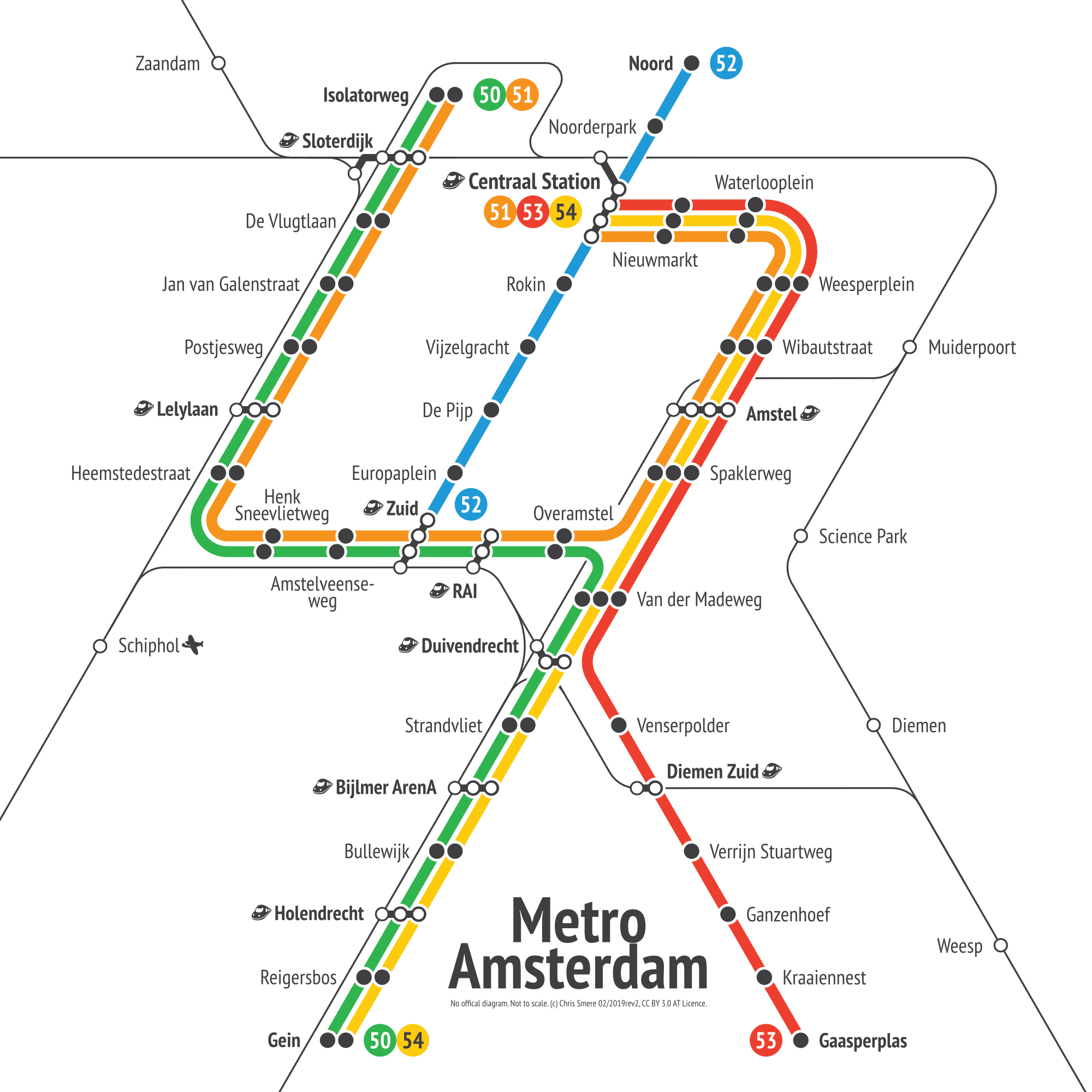
affinity designer Amsterdam - Metro Transit Diagram
transitdiagrams replied to transitdiagrams's topic in Share your work
Thank you! And you are right. If I'd make a map with trams this approach wouldn't work. This is a metro and rail diagram only - as one may find in metro card and pocket city maps. What would be an idea is to indicate transfers to trams at each station. With line numbers or just with a the general indication that tram is available. -
affinity designer Amsterdam - Metro Transit Diagram
transitdiagrams replied to transitdiagrams's topic in Share your work
Thank you so much and also thanks for having a look at my Behance portfolio! I am glad you like it! -
affinity designer Amsterdam - Metro Transit Diagram
transitdiagrams posted a topic in Share your work
Hi - it's me again :-) I do transit maps (diagrams) for fun in my spare time to relax. Here is another one from my archives: made this unofficial Amstersam metro map in February 2019. It shows the metro network and additionally the train lines Feedback is always appreciated. Have a nice weekend!