Search the Community
Showing results for tags 'transit map'.
-
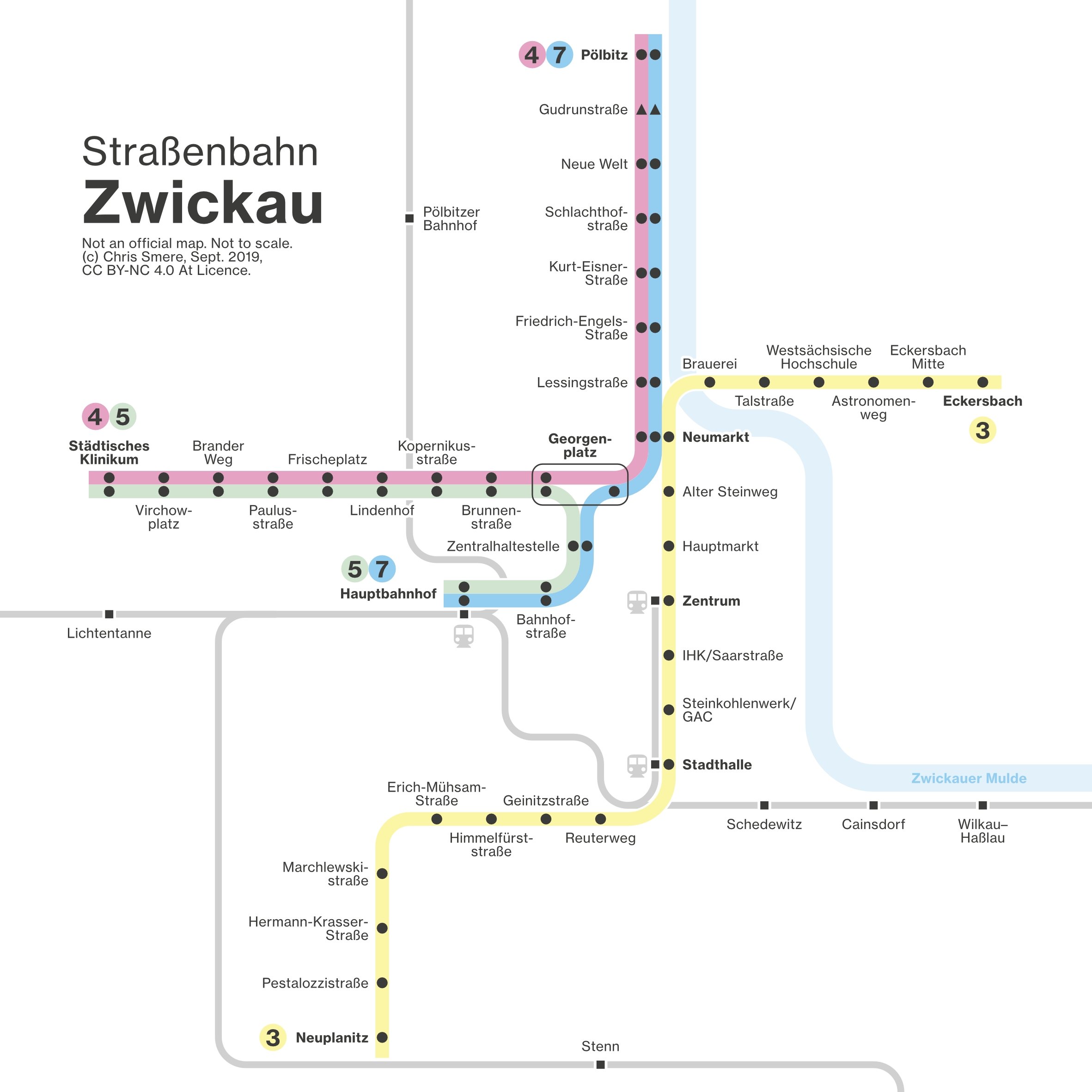
 Hey you all :-) I do love making transit maps and diagrams for fun in my spare. This time a super quick “3.5 hrs evening while watching TV” project show the trams and trains in Zwickau, Germany. Hope you enjoy it as much as I did when making it. Any feedback is of course appreciated and welcome.
-
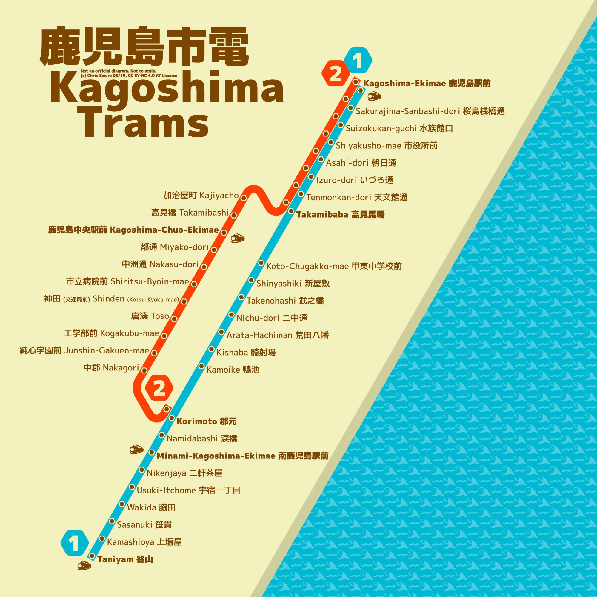
Hey! I do transit maps and diagrams for fun in my spare time. Here is another one I did a few months ago - in March. In bright and dark. It's the tramway network in Kagoshima, Japan. What do you think about it? Have a great week! Chris
-
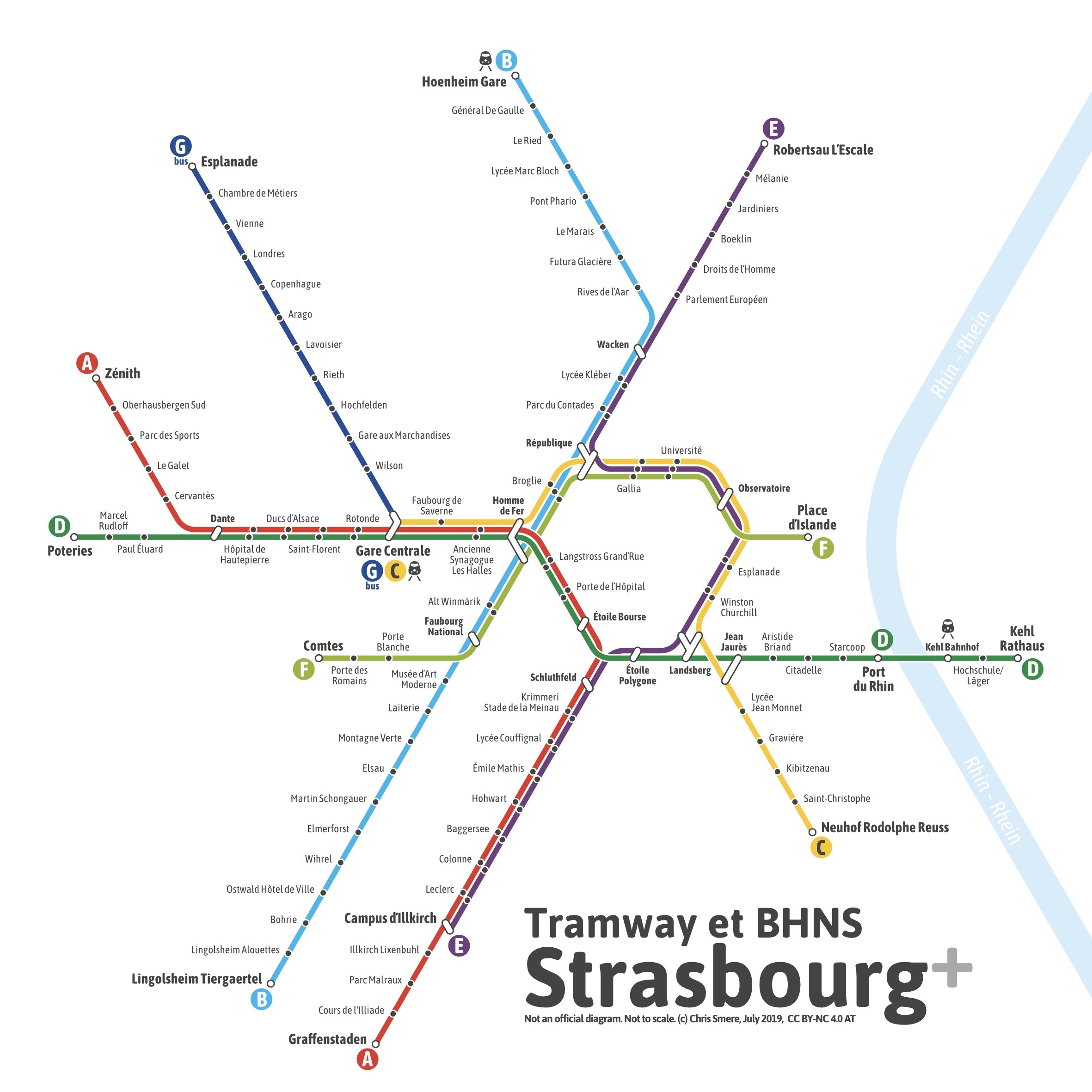
Hey :-) I do transit maps and diagrams for fun in my spare time - if you want to know a little bit more about me just follow this link. This was a rather quick design started on a Tuesday afternoon and was finished due to breaks and beers on Thursday evening at the End of June. Posted it on Instagram and Twitter back then. Here it is - my unofficial transitdiagram of the tramway (and BRT line) network of Strasbourg in France. Actually I have done two versions: one showing the 2019 situation (plus two planned stations on the D line) and the other one showing also the near future expansions included (two more stations on the D line, extensions of the A and F lines). Have a nice week! And of course: Feedback is always welcome and appreciated. Chris
-
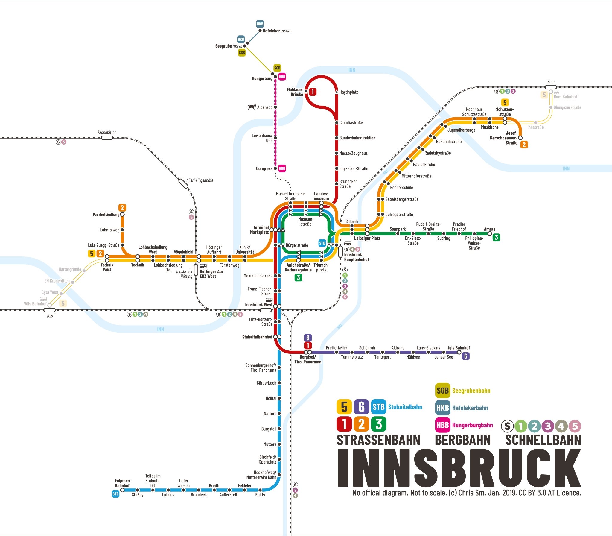
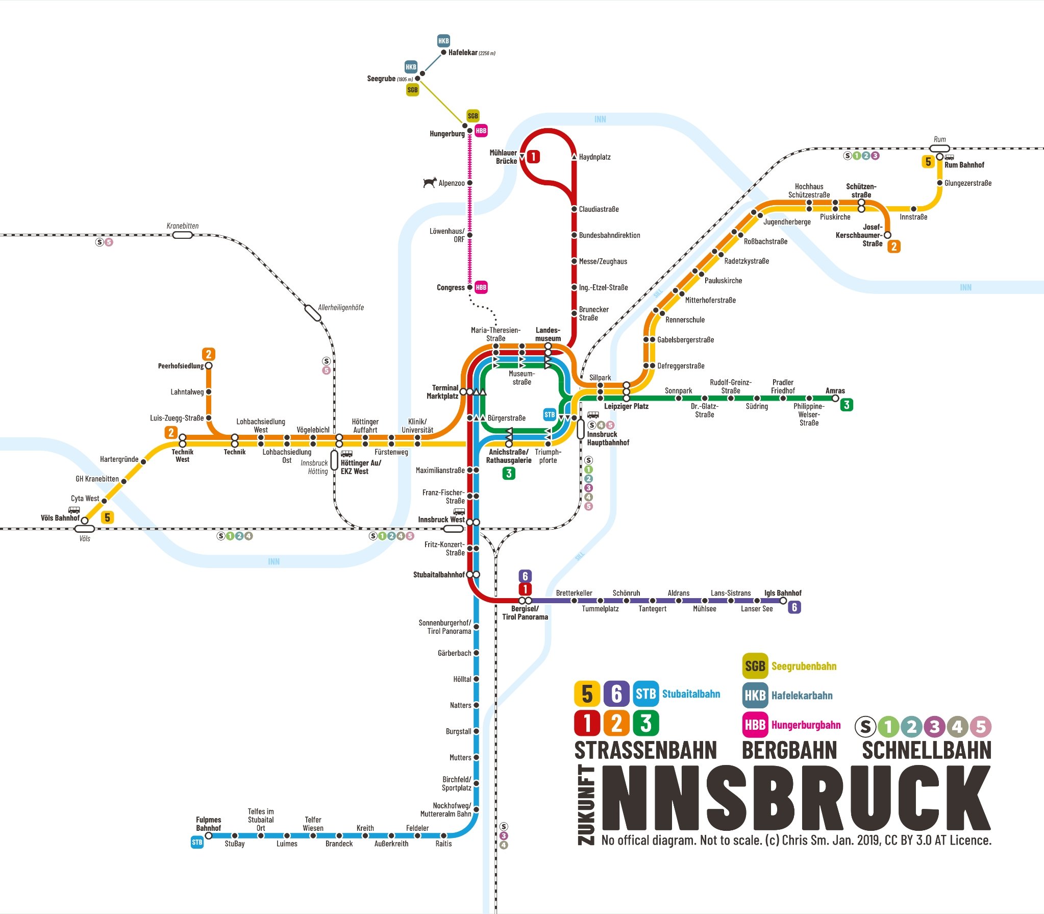
Hello I love doing transit maps or diagrams in my spare time - just for fun. This time I want to show you the tram network of Innsbruck, Austria. In addition to that I have also included mountain railways and commuter railways in that area. The first map shows the situation of right now - with lines 2 and 5 partially operational: The second map shows the situation after lines 2 and 5 are fully open: As usual, feedback is always welcome :-) Have a nicd day! Chris
-
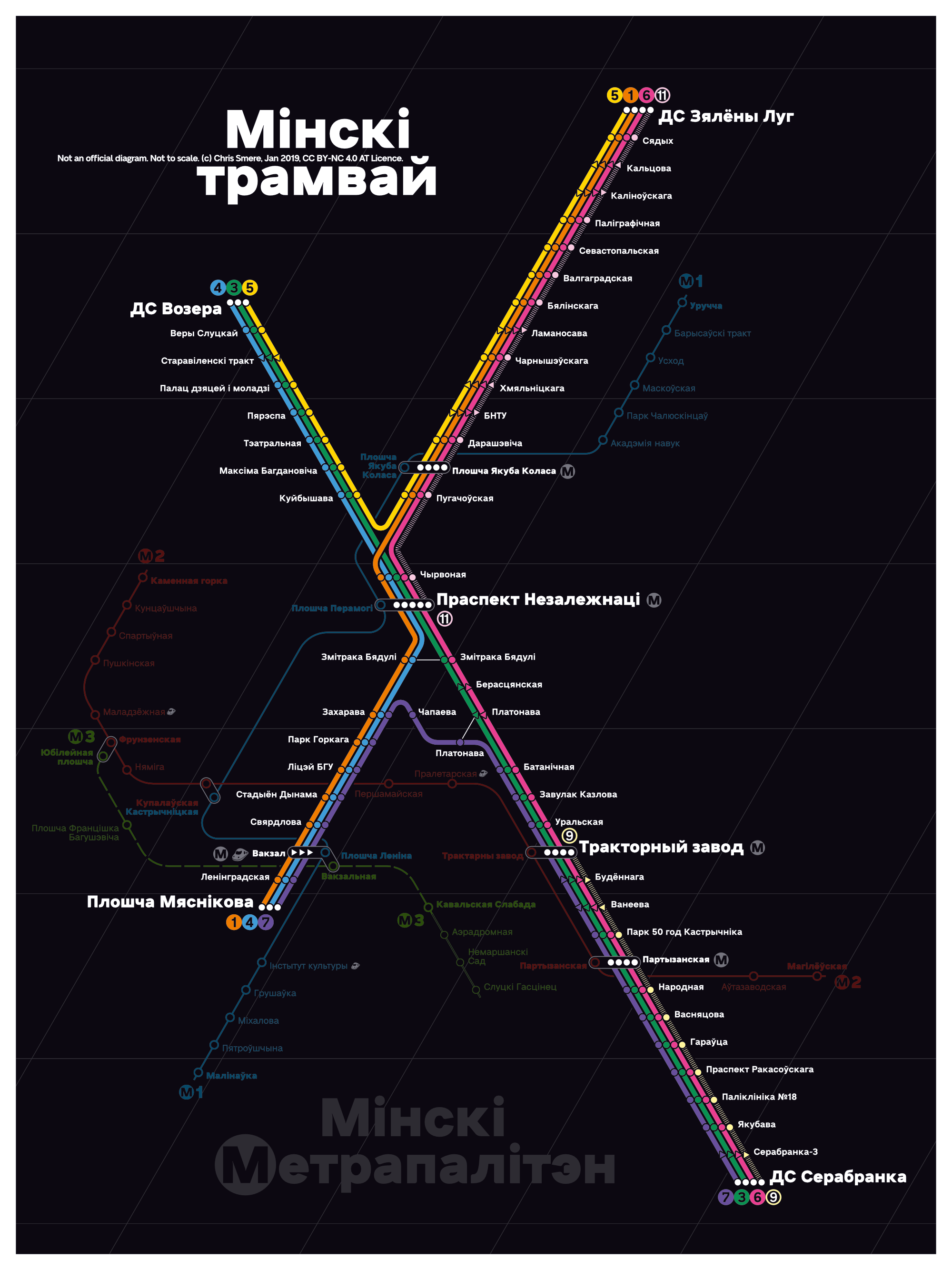
Hey again :-) I make transit maps (diagrams) for fun in my spare time to relax. Here is my unofficial approach for a transit diagram of the tramway system in Minsk, Belarus. To see how it connects with rail and metro I have included it underneath in a more subtle way. As always - all feedback is appreciated and welcome! Have a great day, Chris PS: @Wosven in this case the whole tramway network with its connections is shown :-)
-
Good evening :-) I do transit maps (diagrams) for fun in my spare time to relax. Here is my interpretation of the Bern trolleybus and tram network. Feedback is welcome. Have a nice start of the week tomorrow! Chris
- 12 replies
-
- 10
-

-
- bern
- switzerland
- (and 5 more)
-
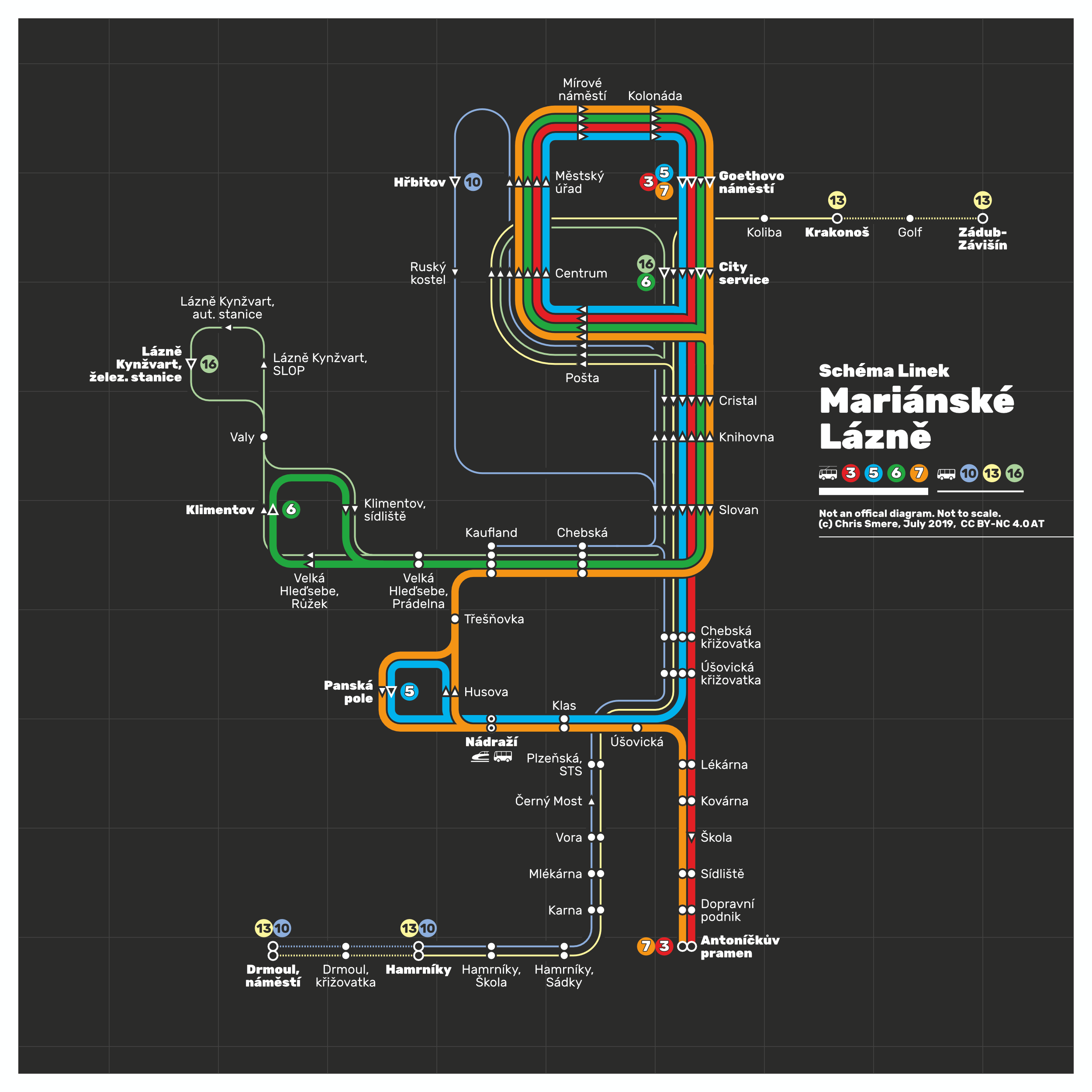
Hi - it's me again :-) I do transit maps (diagrams) for fun in my spare time to relax. Here is another one I was working on the past days and have updated just now: It's my totally unofficial transit map showing the complete bus and trolleybus network of city of Mariánské Lázně (Marienbad), Czech Rebuplic. The trolleybus replaced the streetcar network in the early 1950s. Feedback, corrections, input is always appreciated. Have a nice Thursday night =) Chris
- 14 replies
-
- 8
-
-
- bus
- trolleybus
- (and 5 more)
-
Hi! I do transit maps (diagrams) for fun in my spare time to relax. Here is one I was doing on Monday and Tuesday and updated yesterday: It's my totally unofficial transit map showing the the tramway (light rail) network of Eskişehir, Turkey. It has quite an interesting system with many loops. And what's really nice is that they have meter gauge. Feedback, corrections, input is always appreciated. Have a nice Thursday =)
- 14 replies
-
- 9
-
-
- eskişehir
- transit map
- (and 4 more)
-
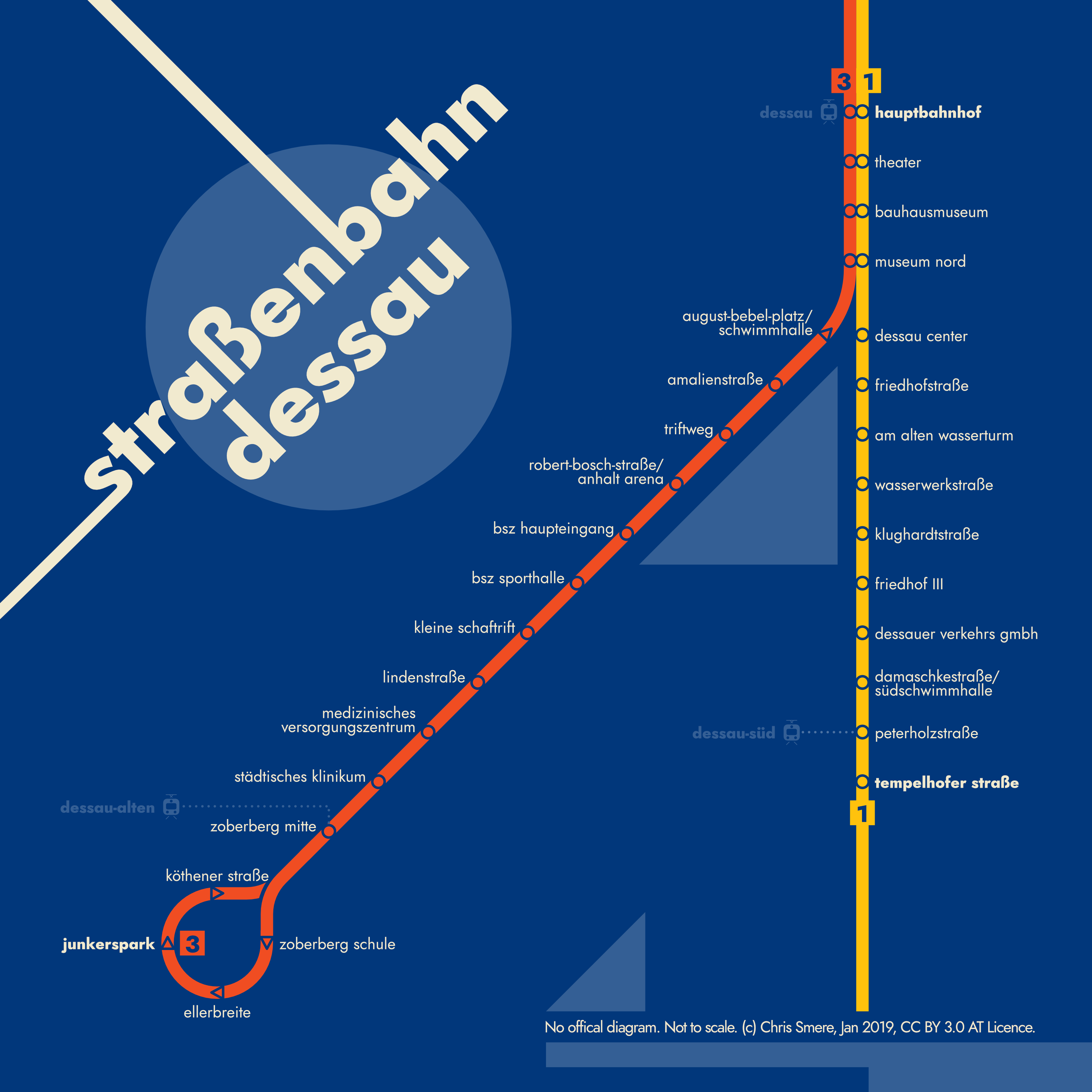
Hi :-) I do transit maps (diagrams) for fun in my spare time to relax. Here is another one of my recent works: a Dessau (Germny) streetcar system map in my own interpretation (unofficial of course). The style is highly inspired by Bauhaus. Hence I am paying homage to this design movement which influences all my thinking and graphic design. The whole map is entirely done with Affinity Designer. If you have any thoughts on it or feedack this is much appreciated. Have a great day/night! Chris
- 18 replies
-
- 11
-
-
- dessau
- transit map
- (and 3 more)
-
affinity designer Lille - Tramway and Métro Transit Map
transitdiagrams posted a topic in Share your work
Hello again :-) I do transit maps (diagrams) for fun in my spare time to relax. Here is another one of my recent works: a Lille (France) Tramway and Métro system map in my own interpretation (unofficial of course). I have included railways and their stations as well. The whole map is entirely done with Affinity Designer. If you have any thoughts on it or feedack this is much appreciated. Have a great day/night! Chris
- 17 replies
-
- 6
-
-
- transit map
- lille
- (and 1 more)
-
Hey again :-) I do transit maps (diagrams) for fun in my spare time to relax. Here is another one of my recent works: the Sarajevo Tram and Trolleybus Network in my own interpretation (unofficial of course). By the way: there is no official diagram and a pride month edition as there aren't official colors too. The whole map is entirely done with Affinity Designer. If you have any thoughts on it or feedack this is much appreciated. Have a great day! Chris
- 7 replies
-
- 9
-
-
- sarajevo
- transit map
- (and 3 more)